
Introduction to the Integrated Processing System of International Geochemical Mapping Data (Geochem Studio IV1.5)
The International Geochemical Data Processing and Mapping System (Geochem Studio IE) developed on the basis of the ArcGIS platform, by the Institute of Geophysical and Geochemical Exploration (IGGE) CAGS, CGS, is an efficient, practical and applicable software for geochemists around the world through the automation and intelligence of work plan, data processing, map compiling, map layout, etc.
This system includes ten function menus, supports both Chinese and English, the main interface and main functions are shown in Figure 2.
Deploy: It mainly includes functions such as fishing net generation, stream system extraction, slope calculation, point layout, etc., which realizes the automation and visualization of the layout of stream system sediment sampling, and can be converted into data files acceptable to the sample collection system. It lays the foundation for field sampling.
Check: It mainly includes two functions: data check and data overview. The data check checks the illegal characters, duplicate points, flying points on the analyzed data, and realizes the automation and visualization of the iterative elimination process (normal distribution test). The initial data overview can help users to have a preliminary understanding of the data by viewing point distribution and element distribution trends.
Statistics: It mainly includes functions such as common parameter statistics, R-type cluster analysis and factor analysis, and abnormal parameter statistics. Statistical analysis results and graphs can be obtained by performing common parameter statistics on the data; clustering and factor analysis can be used to conduct classification and combination research on the data; the visualization function can be used to perform statistical analysis on abnormal parameters.
Processing: It mainly includes discrete data gridding, which can automatically set grid spacing and search radius according to data of different densities, provides a visual window to view parameter settings, and cross-validates the results, and can generate grid data in batch.
Maps: It realizes the automatic and intelligent compilation of actual material map, point data map, point symbol map, geochemical map, single element abnormal map, combined abnormal map, comprehensive abnormal map, abnormal analysis map and histogram, making the production of all types of geochemical maps simple and convenient.
Layout: It mainly includes single layout design and multiple layout application, one layout design can be applied several times, making the layout of series of diagrams of multiple elements automatic, fast and consistent.
The original intention and purpose of developing this software is to provide the most advanced software technology for the member states or participants of the UNESCO International Center on Global-Scale Geochemistry, and to contribute the power of information technology to the advancement and development of international geochemical mapping. Hereby, we hope that geochemists around the world can see it, use it and like it. If so, we would be extremely honored!
If you’re interested in our software, please feel free to contact us.
Telephone: +86 0316 2267751
Email: 875988352@qq.com

Figure 1 System startup interface
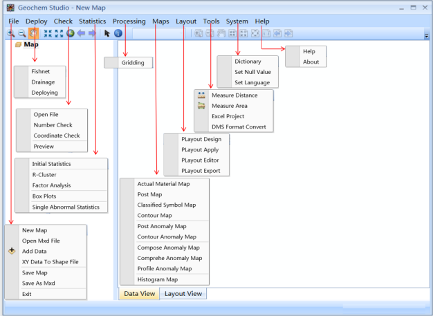
Figure 2 The main interface and functions of the system
Software download:
/uploads/editor/26/b6fd655bbd939aa7575c11e82be49e.zip